Tampa sits barely 48 feet above sea level on a limestone platform riddled with sinkholes. In 2023 alone, Florida's insurance market tightened substantially for properties without subsurface verification, and the city's expanding Westshore district has pushed new foundations into terrain where paleokarst voids hide deep below the surface. Our lab runs vertical electrical sounding surveys across Hillsborough County to map those resistivity contrasts before excavation begins. The method sends current into the ground and reads the potential difference, generating a stratigraphic profile that distinguishes saturated clay from pinnacled limestone without a single borehole. For projects near the bay where saltwater intrusion complicates readings, we pair resistivity data with CPT testing to validate the transition zones, and we reference liquefaction analysis when the upper sand layer exceeds ten feet of thickness.
A resistivity drop below 15 ohm-meters in Tampa's coastal corridor usually means saltwater has reached the freshwater lens—critical intel for any deep excavation within two miles of the bay.
Methodology applied in Tampa Florida
Local geotechnical conditions in Tampa Florida
ASTM D6431-18 frames electrical resistivity as a reconnaissance tool, but in Tampa the stakes climb fast when a hidden cavity sits beneath a planned shear wall. The IBC Chapter 18 requires that foundation investigations address the presence of solution-weathered rock, and Florida Statute 627.706 compels sinkhole data disclosure for certain insurance policies. Skipping VES on a site near the city's historic sinkhole corridor—stretching from Lutz through Carrollwood—can lead to differential settlement that no amount of post-construction grouting will fix cheaply. The risk compounds when resistivity lows coincide with high groundwater conductivity from tidal influence; our field crew calibrates against local water well logs from the Southwest Florida Water Management District to flag false positives before they reach the report.
Our services
Our Tampa resistivity services are structured to match the stage of your project, from preliminary site screening to detailed anomaly mapping. Each package is quoted based on lineal footage and target depth.
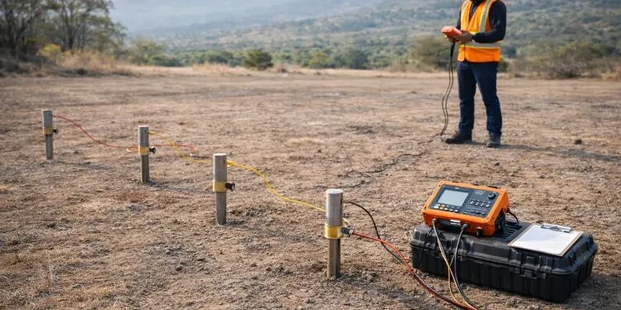
Single-sounding VES survey
One vertical electrical sounding point with Schlumberger array, ideal for confirming depth to limestone on residential lots or small commercial parcels. Includes processed 1D inversion curve, interpreted layer thicknesses, and a brief engineering memo.
Multi-line 2D ERT tomography
Multiple parallel or crossing resistivity lines for site-wide karst mapping. We deliver 2D inverted resistivity sections with annotated anomalies, depth-slice maps at specified elevations, and a comprehensive report signed by our field geophysicist.
Common questions
What does a VES survey cost for a typical Tampa lot?
For a standard residential or small commercial parcel in Hillsborough County, a single-sounding VES or short 2D line typically runs between US$710 and US$1,100. Final pricing depends on access conditions, line length, and whether we need to coordinate utility clearance. We provide a fixed-price quote after a brief site walk.
How deep can electrical resistivity soundings see in Florida limestone?
With a Schlumberger array and a maximum AB/2 spacing of 200 meters, we routinely achieve 60 to 70 meters of penetration in Tampa's limestone terrain. Actual depth varies with ground conditions: dry sand near the surface will limit current injection, while saturated clay can reduce the effective depth slightly. For deeper targets, we recommend combining VES with seismic refraction.
Can resistivity tell the difference between a water-filled void and solid rock?
Yes—that is one of its strongest applications in Florida karst. A water-filled cavity typically reads below 50 ohm-meters, whereas intact Suwannee Limestone often exceeds 1,000 ohm-meters. An air-filled void can read very high, but the contrast is still sharp. We cross-reference the results with local water-table data to separate true cavities from perched saturation zones.
How long does a resistivity survey take, and when will I get the report?
Fieldwork for a single VES point or a short 2D line usually wraps up in half a day. Larger multi-line tomography projects may take two to three days on site. The processed report with interpreted cross-sections and anomaly picks is delivered within five business days after data acquisition, and we can expedite to 48 hours for time-sensitive foundation decisions.