The most common mistake on Tampa excavation projects is treating monitoring as an afterthought—installing a couple of crack gauges and calling it a day. That approach falls apart fast in our geology. Between the surficial sands, the underlying limestone of the Hawthorn Group, and a water table that sits barely a meter below grade in many parts of the city, the ground here doesn't forgive guesswork. A proper excavation monitoring plan ties directly into the project's risk register, using real-time inclinometers, piezometers, and settlement points to track what's actually happening behind the shoring. The data feeds the observational method, letting the contractor adjust support pressures or dewatering rates before a problem escalates. For deep excavations near Tampa's older infrastructure—think downtown or Ybor City—this isn't optional. It's the difference between a controlled dig and an emergency response. A solid baseline starts with knowing your soil profile, so we often pair monitoring with an SPT drilling program to calibrate instrument thresholds against the actual stratigraphy encountered on site.
In Florida's high water table, monitoring isn't about confirming things went well—it's the feedback loop that keeps an active excavation safe day by day.
Methodology applied in Tampa Florida
Demonstration video
Local geotechnical conditions in Tampa Florida
Florida Building Code Chapter 18 and ASCE 7-22 define the minimum lateral earth pressures and surcharge loads for shoring design. In Tampa, these are not just academic equations. The combination of a shallow water table and the potential for limestone pinnacles means that a soldier pile wall designed to code can still face localized overstress if the monitoring data isn't reviewed continuously. The biggest risk is a sudden inflow of water through an undetected solution cavity in the limestone, which can destabilize the excavation face in minutes. A well-designed monitoring plan places piezometers at multiple depths to catch the pressure drop that precedes such an event. For deep excavations near critical facilities, we often recommend supplementing the standard program with a CPT test to map the subtle changes in tip resistance and sleeve friction that indicate a karst feature before the excavation reaches it.
Our services
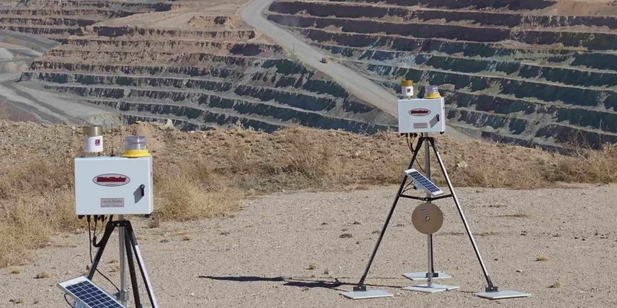
Our excavation monitoring services in Tampa cover the full lifecycle of the dig, from baseline surveys through post-construction documentation. The team deploys calibrated instrumentation and delivers clear, actionable reports so the contractor can make informed decisions on site.
Comprehensive Monitoring Plan Implementation
Installation and daily monitoring of inclinometers, piezometers, settlement points, and crack gauges. We handle the baseline condition surveys, instrument calibration, and weekly reporting packages that meet the requirements of the geotechnical engineer of record.
Vibration and Ground Movement Control
For sites adjacent to sensitive structures or utilities, we deploy seismographs and automated total stations to track ground-borne vibration and lateral movement in real time, with SMS alerts tied to action levels defined in the project's protection plan.
Common questions
What does a typical excavation monitoring program cost in Tampa?
The cost depends on the number of instruments, monitoring duration, and reporting frequency. For a standard commercial excavation with a 3-month monitoring period, budgets typically range from US$910 to US$2,140. A more extensive program with automated instruments and real-time data access will be priced accordingly after a site review.
Which instruments are mandated for deep excavations in Florida?
The Florida Building Code requires a monitoring plan for excavations deeper than 1.5 meters or those that could impact adjacent structures. While no single instrument is mandated, the plan typically includes inclinometers to track wall deflection, piezometers for groundwater pressure, and optical survey points for settlement. The specific array is designed by the geotechnical engineer based on the site's risk profile and the proximity of neighboring buildings.
How often should monitoring data be reviewed during construction?
Inclinometer and piezometer data should be reviewed daily during active excavation and shoring removal. Settlement points and crack gauges on adjacent structures are typically read weekly unless construction activity triggers an alert level, which then shifts the frequency to daily or continuous. The key is having a clear action plan so the superintendent knows exactly what to do when a reading hits the threshold.
Does the monitoring plan cover the dewatering system's performance?
Yes. A proper plan includes piezometers placed both inside and outside the dewatering influence zone. By tracking the actual drawdown curve against the design predictions, the field team can verify that the well system is performing as intended and that off-site wells or environmentally sensitive areas are not being inadvertently impacted.